PRECISE GLOBAL TECHNOLOGIIES
PRECISE GLOBAL TECHNOLOGIIES
+123 456 789 33
Kalukatti Rd, Vellamodi,
Ganapathipuram,
Tamil Nadu 629202
mrittikarch@gmail.com
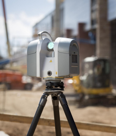
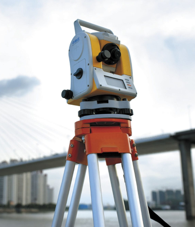
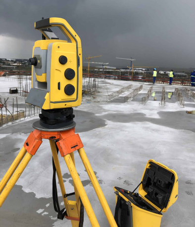
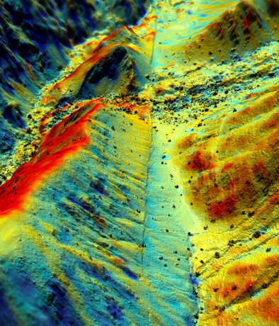
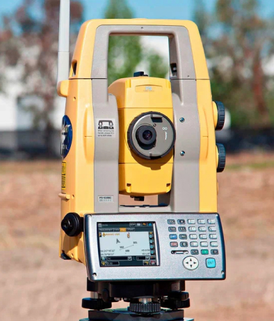
A laser rangefinder stands as a sophisticated tool celebrated for its ability to swiftly and accurately measure distances between multiple points while simultaneously capturing intricate surface details of diverse objects, structures, and environments. At the moment, laser scanning technology is highly regarded for its unmatched precision and the intricate 3D imaging it offers. In our pursuit of tailored 3D object representations to meet project requirements, we rely on state-of-the-art 3D laser scanners, which can seamlessly employ both active and passive laser technologies. Moreover, these scanners are versatile instruments capable not only of creating 3D models but also of generating point clouds of geometric surfaces, scanning topographical features, and conducting non-destructive structural assessments.
The Building Information Model (BIM), consisting of coordination, visualization, and information, serves as a comprehensive documentation process that fosters collaborative workflows through the seamless integration of numerous metadata layers.


Initially employed in the offshore sector, our dimensional control capabilities were primarily used for precise surveys, crucial for achieving first-time fit-up. However, our expert surveyors have since extended their application to the engineering, manufacturing, marine, aviation, and automotive sectors. Through our participation in various large projects related to offshore fabrication and dimensional control services, we have enhanced site safety, minimized work scope, reduced labor costs, and enabled businesses to conduct fabrication in their preferred locations. Furthermore, our contribution has been instrumental in quality assurance and quality control (QA/QC).
By making use of virtual tours, you and your clients can seamlessly immerse yourselves in a realistic virtual environment from the convenience of your homes. This innovative method is excellent for piquing people's interest and presenting your company in a distinctive and captivating fashion.
Virtual tours provide the convenience for your customers and clients to easily examine a physical location via their laptops or cellphones, resulting in time savings for both parties. This, in turn, enables you to refocus your efforts on other aspects of your business or cater to a specific group of highly interested clients. Virtual 360° Tours give potential customers the freedom to explore a property at their own pace and as often as they desire, creating a perpetual open house experience.


Ground Penetrating Radar (GPR) stands as a valuable method for utility sensing, encompassing applications such as mapping gas, water, sewage, electricity, telephone, and cable utilities. Moreover, it excels in the detection of pre- and post-tensioned stressing ducts and steel reinforcing bars, enabling in-depth inspections of reinforced concrete structures.
At the heart of digital twin technology lies engineering data, which empowers engineers to take charge of their assets. By facilitating connections between the right individuals, relevant data, and processes, engineers can attain holistic insights, promptly identifying the essential steps and strategies for achieving enduring performance improvements.


Our capacity allows us to furnish customers with exceptionally precise data, which, in turn, empowers them to enhance their execution strategy through the distinctive amalgamation of sophisticated technology and methodologies.
Through the use of a Geographic Information System (GIS), geospatial data is acquired, stored, edited, analyzed, and can even be reproduced. GIS employs layered data, with each layer representing different types of geographical information, such as forest cover, road networks, vegetation, and more. This wealth of information is of great importance to contractors and engineers involved in large-scale projects, particularly for surveying applications. Geospatial surveying provides a means for a thorough exploration and comprehension of the surrounding environment.

To optimize the transportation of goods, the internal engineering department carries out route and road surveys as part of the planning process.
Our technical services include project planning, budget calculation, and project execution. Prior to providing these services, we conduct an initial informational route survey and road survey. The information gathered during these surveys will be used to create and finalize the transportation plan.
Laser-based scanners utilize trigonometric triangulation as a method to precisely capture a 3D geometry through millions of data points. In this procedure, a LiDAR device projects one or more laser lines onto an object and utilizes one or more sensors to capture the reflected light. The known relative positions of the sensors in relation to the laser's source enable the estimation of the laser light's reflection angle, thereby enabling accurate measurement of data points in the subsequent steps.
Our diverse surveying services span across Land, Buildings, Underground, Site Engineering, and Monitoring. These offerings are not constrained by geographical boundaries and cater to projects of diverse scales, encompassing both simple one-off tasks and intricate multi-package designs.
If you require topographical surveys, land surveying, building surveying, construction surveying, 3D laser scanning, GPS, or structural monitoring data for your project, feel free to reach out to us today. Our services are professional, budget-friendly, and can be customized to meet your specific needs.
Topological mapping, derived from a topological survey, is a vital component of every engineering design and construction project. The primary objective of the Topographic Road Survey is to visually represent geological symbols for both man-made and natural features, including subsurface elements. Additionally, it comprehensively includes any possible infrastructure and building lines that may be relevant within the specified area.
Our utilization of cutting-edge technologies and skilled operators enables us to perform drone topographic surveys of the terrain and 3D aerial scanning with precision. Furthermore, we can supply you with top-notch bathymetry data and digital aerial photographs.